User questions (upper panel) inform the context of landscape (field) suitability factors giving a prioritisation between 16 management measures.
Lower panel tabs allow exploration of each measures’ concepts, evidence, guidance and potential pollution effectiveness.
A result table shows potential coherence vs conflicts between the dynamic (question-led) suitability factors at field-scale against possible catchment-scale pollution reduction goals (via static, effectiveness scores for different pollutants, determined by an expert group as the upper ceiling for well-designed and maintained measures). It is important to note that measures can be combined to reinforce effects if pressures dictate (a treatment chain effect).
To aid viewing the upper panel questions and results table, or lower pane measures tabs you can click on the "Shrink" and “Enlarge” buttons at top or bottom. Please consult the user manual and tool guidance video available through the web entry page for detailed terminology definitions and prioritisation rules.
Input instructions: The top tabs (left to right) guide the user through the field-scale landscape context questions and user help. After a tab is complete a tick (✔) will appear to the right of the name in the set of buttons above. “Reset” clears all inputs.
Outputs: After a tab is complete any measures identified as highly unsuitable will be shown in red. After all tabs are complete the suitability of all measures will be calculated and displayed by the results table prioritisation (table rows) and a common colour coding to the lower measure tabs.
Storing inputs and results: When all tabs are complete the “Inputs & Results Log” page will generate a web-link that contains all the settings you have made. This can be saved or shared with others. When this link is clicked it will load the page with the buttons and check boxes selected.
Field specific pressures
The field specific pressures on your soils are determined by whether your soil is mineral or peaty. Please select the appropriate option below to continue. Is your soil mineral or peaty?
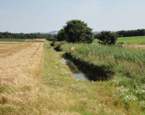
Surface runoff, sediment and total P supply
More info...Please answer for non-extreme rainfall events and the combination of questions derives likelihood of runoff risks and the measures selection include some safety margin for risk.
Are the soils freely, moderately, or poorly draining?
More info...This can be answered from general field observations across non-extreme events, or from soil map resources.
Are the hillslopes flat (<2°), gentle (2-5°), moderate (5-10°), steep (10-18°), very steep (18-30°)
Is the soil texture clayey (fine), loamy (medium), or sandy (coarse)
More info...This can be answered from direct field observations of texture, or from soil map resources.
What are the soil's peaty characteristics namely: lowland drained, lowland undrained or upland blanket peat
Modify soil erosion risk for effects of land cover and cropping practices
Crop risk classes used to modify a nine-class system for inherent topsoil erosion risks
Low risk
Grassland: The continuous cover and stabilising effect of grassland acts to lower the soil erosion risk by one class
More info...Grasslands provide a complete and continuous cover of soil by vegetation and protection against soil erosion due to the stabilizing capacity of the grass’s rooting system. Therefore, it is assumed that there is less risk of soil erosion in grassland fields and thus the soil erosion risk class was lowered by one class.
Medium risk
Cereal crops: This intermediate situation keeps the field’s soil erosion risk class the same
More info...For cereals, it is assumed that a field’s erosion risk class remains the same because these crop types represent an intermediate situation whereby there is adequate annual plant coverage and thus soil protection, but cultivation practices may cause some degree of soil compaction. Although winter cereals are assumed to be more susceptible to soil erosion than spring cereals, we pragmatically assigned them both medium risk.
High risk
Maize, root vegetables and potatoes: Because of bare land during autumn-winter, soil compaction and aggregate instability due to machinery the soil erosion risk is increased by one class
More info...Soil erosion risk is assumed to be greater in land used for maize, root vegetables and potatoes because this land is often left bare during the vulnerable autumn-winter periods and also due to the greater risk of soil compaction and soil aggregate instability caused by the use of heavy machinery and seed-bed preparation. Therefore, for these crop types the soil erosion risk class was increased by one class.
Low risk
Grassland: The continuous cover and stabilising effect of grassland acts to lower the erosion risk for lowland peaty soils by one class. Upland blanket peats always remain high erosion risk.
More info...Grasslands provide a complete and continuous cover of soil by vegetation and protection against soil erosion due to the stabilizing capacity of the grass’s rooting system. Therefore, it is assumed that there is less risk of soil erosion in grassland fields and thus the soil erosion risk class was lowered by one class.
Medium risk
Cereal crops: This intermediate situation keeps the field’s erosion risk class unchanged for lowland peaty soils. Upland blanket peat is unlikely to have such cropping.
More info...For cereals, it is assumed that a field’s erosion risk class remains the same because these crop types represent an intermediate situation whereby there is adequate annual plant coverage and thus soil protection, but cultivation practices may cause some degree of soil compaction. Although winter cereals are assumed to be more susceptible to soil erosion than spring cereals, we pragmatically assigned them both medium risk.
High risk
Root vegetables and potatoes: Because of bare land during autumn-winter, soil compaction and aggregate instability due to machinery the erosion risk for lowland peaty soils is increased by one class. Such crops not found on upland peats.
More info...Soil erosion risk is assumed to be greater in land used for root vegetables and potatoes because this land is often left bare during the vulnerable autumn-winter periods and also due to the greater risk of soil compaction and soil aggregate instability caused by the use of heavy machinery and seed-bed preparation. Therefore, for these crop types the soil erosion risk class was increased by one class.
Modify adjusted soil erosion risk by any in-field management measures
Select from any of the following in-field mitigation options that apply:
Arable - Cover crops
Arable - Nutrient planning or precision agriculture
Arable - Minimum tillage practices
Arable - Post-harvest management e.g. tramlines, or shallow post-harvest cultivation
Grassland - Rotational grazing or seasonal livestock removal
Grassland - Track runoff management
Grassland - Nutrient planning or nutrient reductions associated with multi-species grass species
Grassland - Cattle restriction from erodible areas
The nature of delivery points
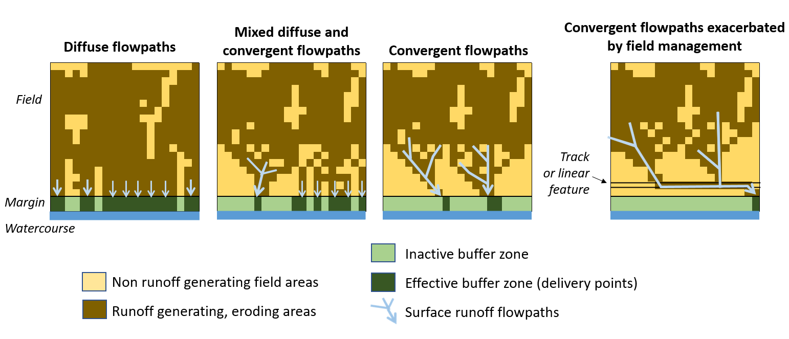
Defining the nature of surface runoff flowpaths (see figure below)
More info...Please answer generally from field observations across years of typical rainfall events. It is likely that the most extreme events led to convergent flows in many situations.
What is the nature of surface runoff observable at field watercourse boundaries during rains: diffuse surface runoff (or rarely runs off the surface), mixed diffuse and converging flowpaths, often convergent flowpaths (e.g. leaving visible surface erosion features)
Determining modifiers on the flowpaths at the field-riparian border
Do any linear features at the field edge tend to gather runoff and divert it to one or a few points leaving the field edge?
Plough step
Vehicle or animal tracks
Gateways or animal congregating areas
Hedge or wall
The nature of the riparian zone
Determine the presence and access of artificial subsurface (tile) drains
Is subsurface artificial drainage present?
Are any existing, small, near-channel wetland features or dominantly wet field corners present in the field margin?
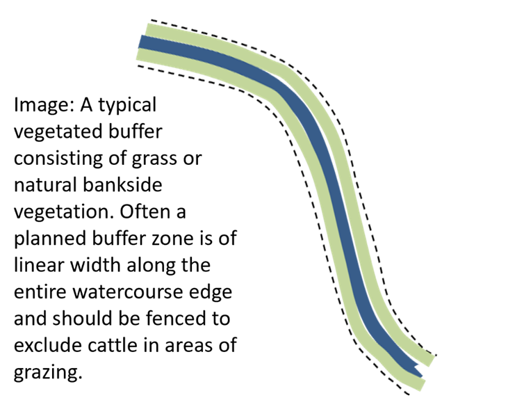
Have you got existing vegetated watercourse buffer zones and are they working?
More info...No, considers that field management continues to within < 2 m from the top of the watercourse bank or that existing field margins allow stream access by cattle; Yes and effective, denotes fenced buffers > 2m are present and are considered to be performing functions of a physical barrier, filtration of water and stopping erosion; Yes but ineffective, denotes fenced buffers > 2m are present but have signs of failing water quality protection, such as erosion or drainage crossing the zone, or bank erosion.
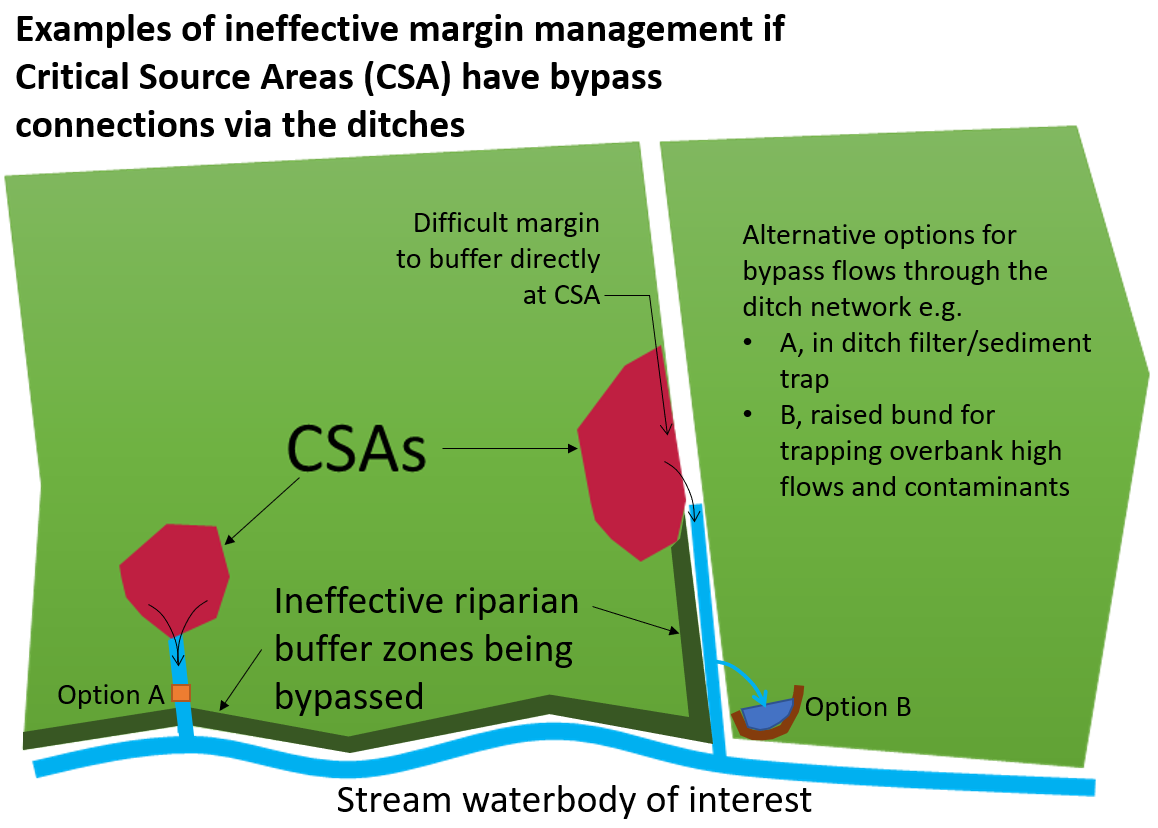
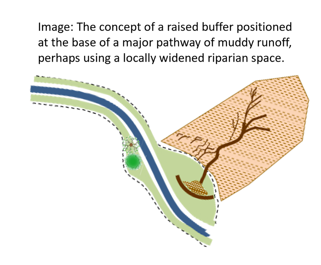
A Critical Source Area in this case is a location with disproportionately high risk of source loading and connectivity to the watercourse
This question considers the specific situation where:
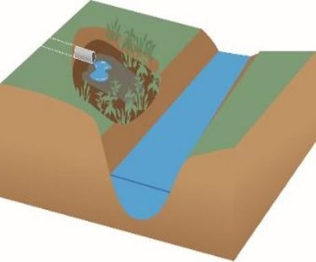
Pollution has already entered an open surface drainage ditch and transport toward the watercourse cannot be controlled by field margin measures (see the diagram);
The pollution that is by-passing the riparian margin measures may be treated by within-ditch and overbank sedimentation measures;
Note this option does not consider the similar bypass of pollution under a riparian margin with a subsurface field drain (this is dealt with elsewhere).
Does the above situation of an open drainage ditch bypassing riparian management occur?
The nature of the watercouse
What type of watercourse
Select the watercourse type:
More info...An open surface ditch is man-made and can be generally distinguished from a natural stream by ditches being straightened, deepened, following field edges and corners with little relationship to natural landscape contours. However, natural streams may also be heavily engineered, but ditches never have an upstream waterbody. Any recommendations of in-ditch measures should be checked with relevant authorities.
Floodplain types
How would you describe any floodplain present?
Watercourse issues
Are there any observable sedimentation issues around the watercourse?
Bank erosion
Cattle access and poaching
Heavily silted watercourses
Additional considerations
Habitat considerations
Are any habitat designations or considerations influential?
Limit site disturbance for terrestrial wildlife
More info...If you propose to undertake riparian activity within (or the activity may affect) a protected area such as a Special Area of Conservation or nature reserve then check with the relevant authorities before undertaking works. Avoid bankside maintenance such as vegetation cutting between March and August.
Sediment loss control required for protected aquatic species
More info...If you propose to undertake riparian activity within (or the activity may affect) a protected area such as a Special Area of Conservation or nature reserve then check with the relevant authorities before undertaking works.
Habitat reasons for not including trees
More info...Avoid tree planting in important sites for waders and other threatened ground nesting birds.
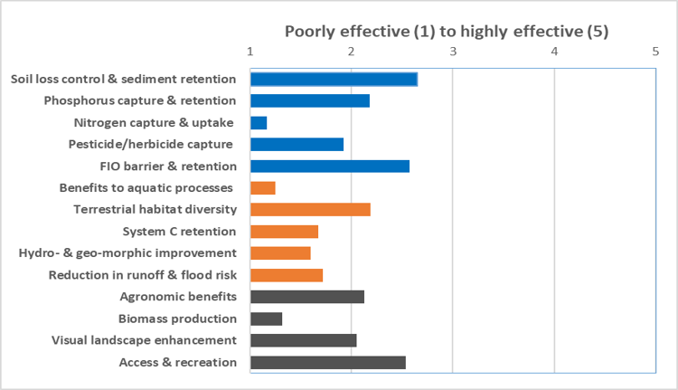
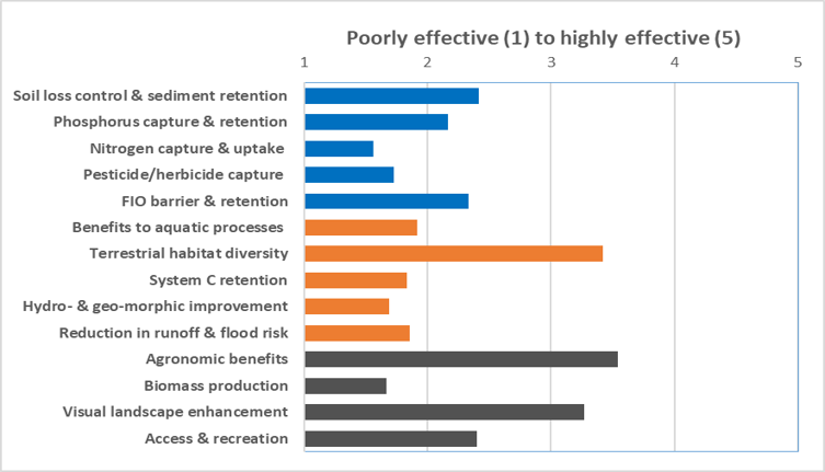
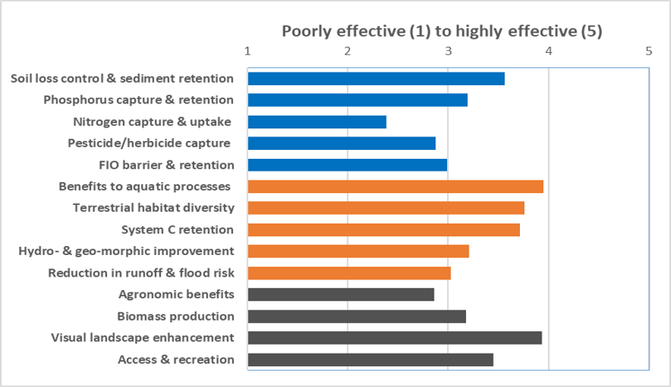
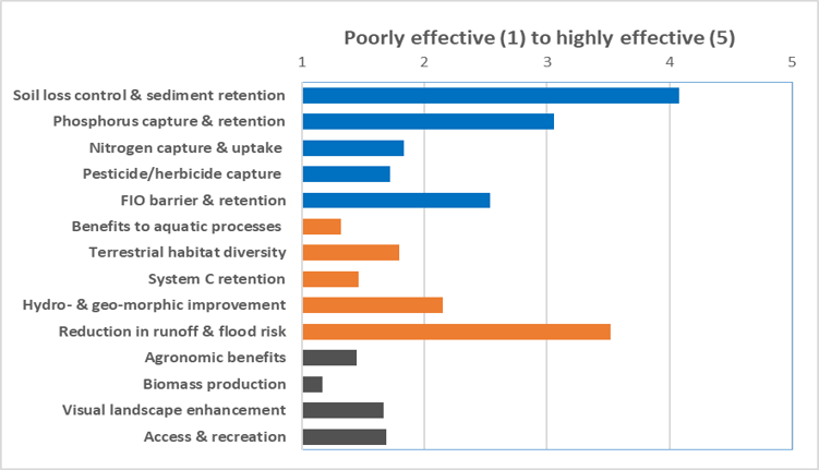
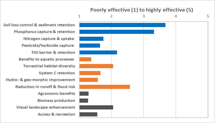
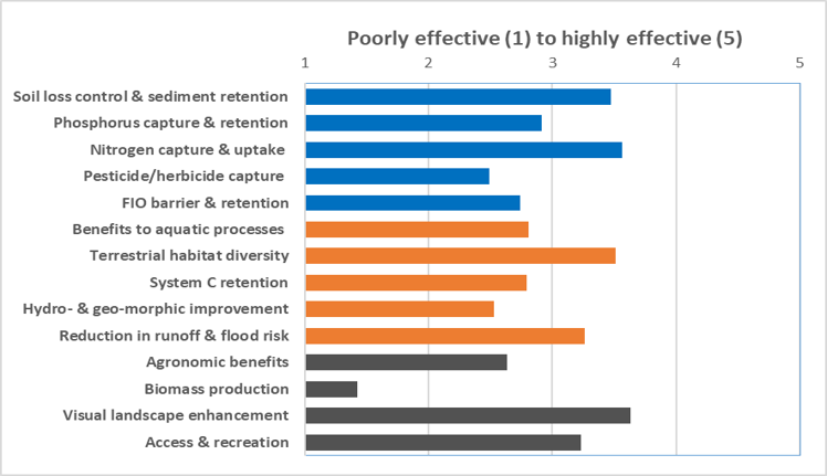
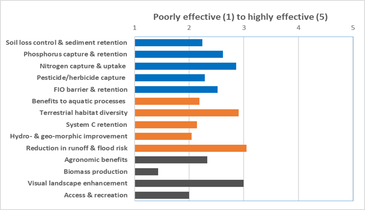
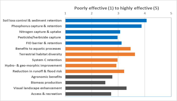
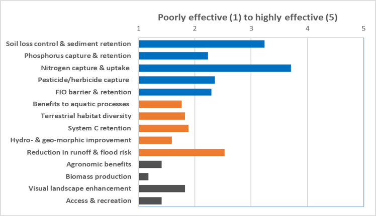
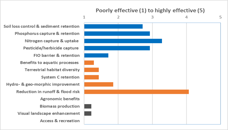
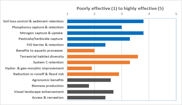
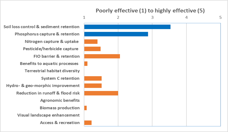
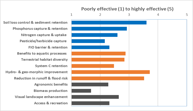
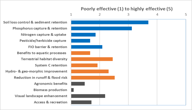
Measure prioritisation (rows: dynamic, based on user inputs) vs potential for pollution effectiveness (columns: static, based on pre-determined expert assessment of the upper ceiling for well-designed and maintained measures).
More information on the measures can be found by clicking on each of the buttons on the lower half of the web page.
The table below shows the non-excluded measures ranked from highly (green), moderately (blue) and potentially suitable (yellow) for the field situation as defined by the answers to questions. Excluded measures are red. Colours here match those used on the measure tabs.
In addition to their suitability for the field situation it is recognised that further prioritisation will likely be based on tackling known catchment water quality issues. The table therefore also indicates the potential effectiveness of the measures for improving water quality for a range of pollutants as High (H), Medium (M) and Low (L) as determined by a panel of experts.
Order of priority based on fit to field-landscape factors
Ability to address specific water quality issues
Sediment
Total phosphorus
Nitrogen
Pesticides
Microbial contaminants (FIOs)
The High (H), Medium (M) and Low (L) refer to the scores of 1-2, 3 and 4-5, respectively, from the expert effectiveness assessment as indicated in the measure tabs.
Reset all of your selected options
If you wish to reset (i.e. clear) all of your selected options and start again please tap the button below.
Please note that YOU WILL NOT be asked for confirmation. Tapping the button below WILL clear all the buttons you have tapped.
Results and inputs
Results - testing
Grass Buffers
Grass buffer strips intercepting surface runoff and providing a phsyical break between agricultural activities and the watercourse
Key concepts
Often considered to be a very effective edge of field measure for separating watercourses from agricultural activity and intercepting overland flow to reduce run-off and pollutants into the stream from upslope fields. Several decades of evidence have developed on grass edge of field filter strips and thsees are very popular as agri-environment measures in riparian contexts. The buffer zone can be a physical break from cultivation activities (fertiliser and agrochemical use near the watercourse), or with a fence, from direct pressures on watercourses by livestock. The buffers can stabilise banks and roughen the riparian zone Width can vary depending on setting but it is increasingly recognised that functions of grass buffers are limited compared to inclusion of other specific aspects and that narrower (several metres) buffers are very limited. There is limited ability other than wide (>10 m) grass buffers to function well for retaining dissolved nutrients, especially groundwater nitrate flows. It is well understood that subsurface artificial drainage pathways can readily pass through buffers and undermine their effectiveness.
Summary of evidence on functions
There is a wealth of evidence on functioning for sediment, total P and to a lesser extent N and pesticides that shows a mixed effectiveness but generally the benefits of grass buffers from relatively narrow widths in terms of water quality, associated with roughness and infiltration that traps particles. Dissolved N and P functioning is worse and more complex to predict at a site. The functionality for faecal indicator organisms (FIO) retention in grassland requires a fenced buffer and this brings management issues for providing off-stream animal watering. Terrestrial habitat functions are potentially low although increasing roughness with tussocky grassland could improve habitat for small mammals and associated hunting birds. Biomass harvesting is counter-effective due to reducing hydraulic roughness and worsened run-off control, although it was recognised biomass harvesting can remove P. Occasional access by animals was considered appropriate but use for vehicular access was likely to be negative.
Main countries where this is practiced
Worldwide, but much evidence comes from U.S., Europe, Australia, Canada, New Zealand
Challenges and limitations, including site-specific factors, planning requirements and particular suitability to farming systems
Need time to establish grasses and stiffer vegetation to form a barrier to surface runoff.
If placed in a livestock field these features need to be fenced.
Reduces the size of field. Could impact on eligibility of land for Pillar I payments in CAP.
Flow can often bypass the grass filter strip area.
Vehicle compaction can make buffers less effective. This includes where sediment builds up on the buffer surface and needs removal or ground reprofiling. Overgrown grass and weeds, especially in nutrient rish, former cropland soils, can increase nutrient cycling and lead to poor biodiversity, necessitating managamant (cutting) of vegetation.
Ability to modify it for site requirements
Grazed buffers offer a form of land management but exclusion of cattle (for microbial contamination of watercourses and bank erosion) is best practice. Temporary sheep grazing can help grass management and resources for manual cutting and removal. The measure is flexible thus lends itself to shorter term agri-environment measures (e.g. proposed schemes under Pillar I).
Critical factors in establishment and ongoing management
This measure requires relatively low management inputs but it still requires a certain level of effort to establish the buffer, for example to establish a grass sward. Sward should be dense and permanent to combat year-round surface flows. Buffer topsoil compaction and rills or gulleys should be removed. Heavy seeding machinery should be avoided (risk of compaction and bank collapse) and is not allowed in UK within 2 metres of the bank. Grass may be cut several times over first 2-years to promote density and control weeds. Once established, the level of maintenance required is potentially low. However, cutting and removing vegetation improves the nutrient retention capabilities and may guard against P leaching, but requires effort. Controlled use of herbicides (spot-treat and weed-wipe only) can remove aggressive weeds or non-native invasive plants. If the buffer is located within a livestock field or if intensive grassland is part of the rotation, then fencing will be required. Avoid poaching by livestock near to the fence. Don't cut vegetation from start of March to end of August to avoid disturbing nesting birds. Avoid trafficking the buffer with machinery, especially in wet weather.
Averages from 25 international experts from an electronic survey during 2022-23. Academic, regulatory and advisory experts were sent this database sheet (without effectiveness scores) and asked to score each attribute (1-5) for measures they were familiar with. The method and results will be explained in a paper linked to this database.
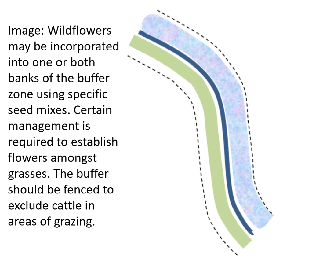
Watercourse buffers
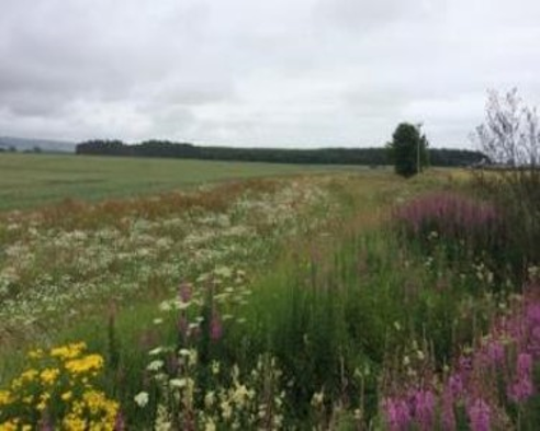
Watercourse buffers with specific wildflower mixtures or altered vegetation for specific outcomes
Key concepts
Here the properties of the grass buffer as a surface runoff filter strip are enhanced by including a variety of 'designer' vegetation to satisfy specific goals. A common example is sowing a mixture of native wild flower seed from a conservation mix. The measure considered here is of specific grasses and herbs (to make the measure distinct to a wooded buffer) that have habitat improvement for plants and associated animals. For example, there may be associated effects for beneficial insects such as pollinators and those predating crop pests. But also 'designer' vegetation may include stiff-stemmed grasses for better erosion control, or nutrient-mining vegetation that can contribute to green manures, or human food crops such as berries and high value specialist hay e.g. for horses.
Summary of evidence on functions
Wildflower buffers can benefit vegetation diversity to benefit invertebrates. But they are unlikely to promote increased numbers of rare plant species. Fencing out livestock from narrow riparian buffers can increase structural diversity of vegetation but has been found to reduce number of plant species and favour competitive weeds, so some form of grazing or cutting is beneficial.
Main countries where this is practiced
U.S., across Europe
Challenges and limitations, including site-specific factors, planning requirements and particular suitability to farming systems
Establishment of wild flowers can be tricky amongst grasses that outcompete them for light and other resources, necessitating ground preparation such as herbicide or physical cultivation.
Any vegetation manmagement should be timed after periods of flowering.
The best habitat diversity amongst vegetation can be gained form buffers having areas of both wetter and freer draining soils.
In some countries lack of regulation of wildflower seeds, leading to uncertified provenance, presents issues. This situation in Ireland, for example, leads to current best advice being to allow natural vegetation to regenerate, as opposed to planting with seeds of unknown provenance.
Wildflower management is eligible for cross-compliance payments.
Ability to modify it for site requirements
Seed mixes may be varied for differing required outcomes and according to local natural communities according to soil and climate conditions.
Critical factors in establishment and ongoing management
Many of the points of management can be drawn from general wildflower field margin guidance. However, for riparian contexts important aspects are: that cultivation is not allowed within 2 metres of the banks so a streamside grass border or a natural established flower band must be used, herbicides and grazing as vegetation management has special rules close to waters. Specialist wildflower seed mixes are available off-the-shelf for different climatic regions and goals. For example, in existing 6 m grass margins for stewardship schemes there is already a recommended grass/wildflower sowing mix. Often competing vegetation must be mechanically removed to allow flowering plants to establish. For this topping to 6-10 cm in the first years can be good and maybe graminicde can be carefully used. Grazing in late autumn may be beneficial if allowed (e.g. sheep would be less impact). Sow from Mar to Sept when soil is moist and warm, by broadcasting onto fine seedbed and rolling. The functionality for FIO retention in grassland requires a fenced buffer and this brings management issues for providing off-stream animal watering. Special survey and planning may be required if diverse or mosaic vegetation on different soil moisture regimes is to be established, or trees and herbaceous mixtures.
Expert effectiveness assessment: Averages from 25 international experts from an electronic survey during 2022-23.
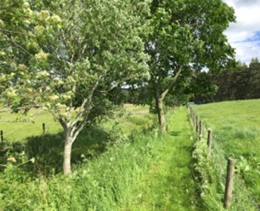
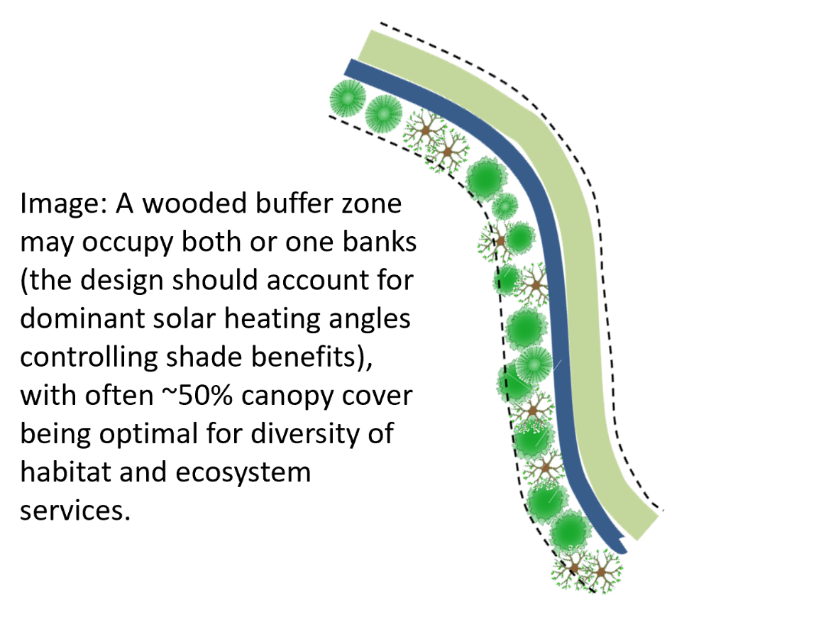
Wooded buffer strips
Wooded buffer strips at watercourse (one or both banks, continuous or scattered)
Key concepts
Inclusion of trees into an otherwise grass buffer benefits many functions associated with longer term nutrient retention, ability to mediate groundwater nutrient pathways, habitat, stream shading and stopping spray drift. Primarily native broadleaved trees are placed along watercourses, with potential to vary management system to maximise pollutant uptake and removal, for example short rotation coppice. Threes can increase surface roughness and potentially soil infiltration, depending on soil wetness to reduce pollutant run-off. They can reduce aerial dispersion and deposition of pollutants to watercourse such as pesticides and ammonia, as well as provide shelter. Trees benefit the aquatic habitat as sources of woody debris that can promote the formation of leaky dams and the formation of riffle and pool structures, for providing shade, cooling water temperatures for the benefit of salmonid fish. Can also improves watercourse hydromorphology. Also they can helps to slow otherwise fast runoff and reduce downstream flood risk. River corridor woodland are habitats in their own right, but can link up wider habitats (e.g. isolated woodland), creating woodland habitat networks and wildlife corridor.
Summary of evidence on functions
Trees are found to stabilise river banks, reduce runoff thereby helping to reduce risks of flooding. The tree planting gives shelter for animals, habitat and enhances woodland connectivity. Tree planting in buffers may especially be beneficial when tragetting areas prone to flooding, bank erosion or suffering elevated water temperatures or areas where woodland connectivity is lacking.
Main countries where this is practiced
U.S., across Europe, Australia
Challenges and limitations, including site-specific factors, planning requirements and particular suitability to farming systems
Need time to establish, with some benefits such as inputs of deadwood being slow to be realised.
If placed in a livestock field, these features need to be fenced.
Reduces size of productive field and can impact crop yield due to shading, depending on aspect.
Flows can be bypassed at depth, although this can be reduced by tree rooting.
Potentially needs access for management such as thinning and eventual harvesting.
Potentially vulnerable to wind blow.
Can increase local flood risk by backing up flood waters and the washout of dead wood.
Limits access to watercourses for maintaining flood embankments, water supply and crossings.
Potential for excessive shade, requiring management.
Potential to deflect watercourse flows, increasing wetness and loss of local land.
Ability to modify it for site requirements
There is much scope to vary and tailor design/structure in line with nature of pollutant, loading and transport pathways. Choice of trees will be varied according to dominant species for the climate and soil conditions. Native species support more biodiversity.
Critical factors in establishment and ongoing management
Most management comes during establishment of trees: getting rid of grass and competing weeds at tree bases is recommended until canopy closure to help trees become established. Some trees can be planted into a weed suppressing geotextile groundcover for small areas, but most are planted directly with spot herbicide treatment used around the tree for several years. Protection from deer is necessary in most places using a tree gaurd and stake for each tree. Harvesting wood will provide biomass but requires effort and can detract from some habitat and shade benefits for a duration afterwards. Access for harvesting machinery must be done with care not to destroy soil structure or leave preferential run-off paths and may give marginal returns on small areas relative to effort.
Expert effectiveness assessment: Averages from 25 international experts from an electronic survey during 2022-23.
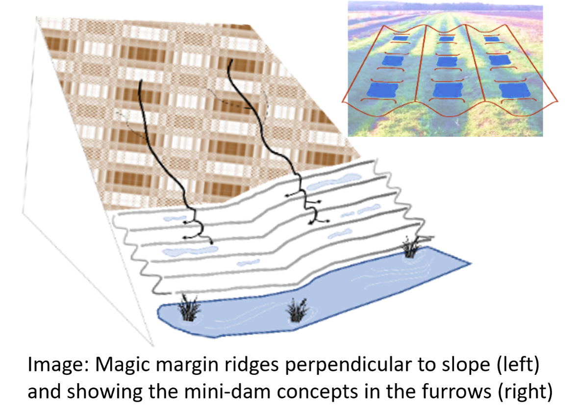
Magic margins
Magic margins
Key concepts
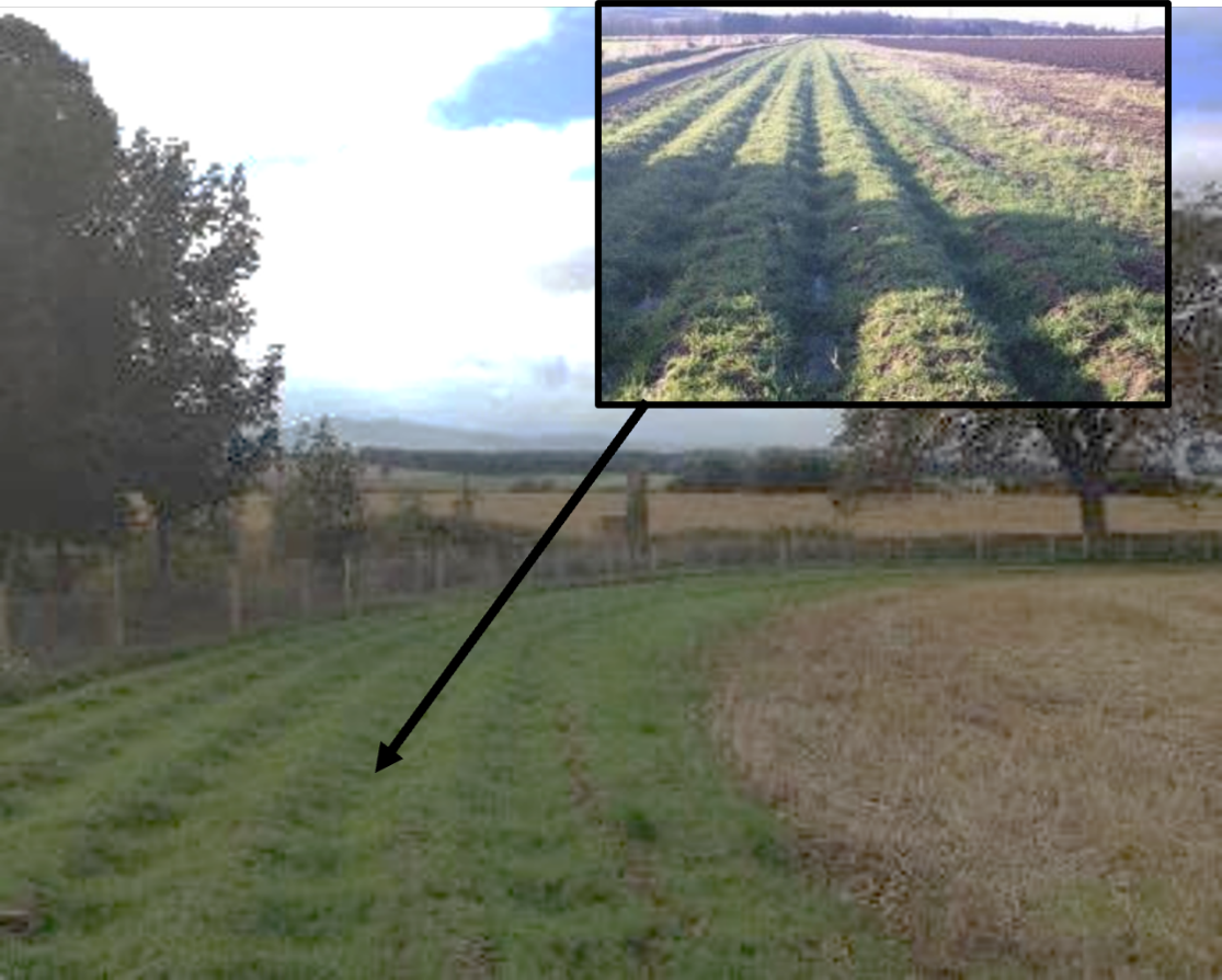
A practical ‘magic margins’ solution to soil erosion was devised by the James Hutton Institute’s Farm, Field & Glasshouse team. These ‘magic margins’ consist of a system of barriers created across the bottom of a sloping field with a potato drill plough and tied ridging machine. The barriers are then sown with a wildflower/grass seed mix to hold irrigation and rainwater and help prevent soil and nutrients being washed off. They also provide additional multiple benefits such as providing a greater habitat and diversity of resources for farmland wildlife, discouraging drivers from venturing into field margins as well as reducing the risk of hare coursing.
Summary of evidence on functions
Magic margins can be a permanent part of the EFA field margin area on field edges to capture run-off from the field (particularly useful where the margins takes runoff from the whole field). The mini-damn created encourage infiltration as opposed to runoff in the margin and structurally resembles a beetle bank. Magic margins may be used as a temporary measure to mitigate specific erosion risks in a given season, e.g. during potato cultivations, after which they may be removed and the whole field area brought back into production. Additional benefits gained from the habitat and resources provided for farmland biodiversity. In the first couple of seasons, nectar and pollen supplies from the newly sown wildflower mixes provide resources for pollinators (primarily bumblebees) and other beneficial insects, particularly the adult forms of natural enemies (hoverflies and parasitoid wasps) whose larvae consume crop pests (mainly aphids). Enhanced activity levels of these insects can improve the pollination of insect pollinated crops (e.g. field beans) and reduce the abundance of pests in a wide range of crops. They have been established effectively in widths ranging from 3m to over 20m.
Main countries where this is practiced
UK
Challenges and limitations, including site-specific factors, planning requirements and particular suitability to farming systems
May be effectively placed in several positions across a slope in order to slow run-off within the field and capture nutrient leaching and eroded soil.
As furrows they need to be carefully placed so not as to act as preferential flow conduits that accelerate erosive flows.
Timing of operations are important as to create bare soil and set up drills during the autumn/winter makes the soil erosion risk higher, thus acting as the cause of the very issue we aim to prevent.
Establishment preferably the year preceding an erosive crop on a risky soil (or at least in spring/early summer) ensures that drills are shaped in good, friable soil conditions and allows time to establish the vegetation essential to stabilise the drills before the wetter winter months following the riskier crop.
As a buffer strip designed to capture eroded soil and any leached nutrition, our permanently established ‘magic margins’ are not suited to wildflower meadow-type management which requires lower soil fertility levels to allow annual flowers to flourish.
Concerns also with wildflower seed provenenance in some countries (see widlflower buffers).
Ability to modify it for site requirements
The dimensions of the trough to peak of the furrows is set by the machinery. However, the width of the margin can be altered to suit the burden of runoff (ie how many side-by-side passes of the machinery are incorporated). Also the vegetation sown onto the margin can be varied both for differing required stability levels and biodiversity requirements.
Critical factors in establishment and ongoing management
To maintain a diversity of flowering resources, the margins would need to be cut periodically and the material removed to help control the build up of nutrients which encourage dominance by the more vigorous noxious perennial weeds. Cut material containing a diversity of plant species can contribute high quality organic matter to the system if returned to the field soil (either pre-composted or as a mulch). This management should benefit habitat and nutrient removal and possible return to the field system. However, cutting, removal and (optionally) composting is a huge task for a comparatively small gain and is unlikely to be often cost effective. A cheaper and less time consuming option is to allow succession of the margins by grasses, with weed control focused on suppression of invasive nettles, thistles and couch. Established tussocky grass species (e.g. cocksfoot and timothy), along with fescues and bents require cutting no more than once every three years and provide a valuable habitat for ground beetles.
Guidance and other resources
Although little exists online the general aspects are: Ground is prepared for cultivation by ploughing (potential use of herbicide on persistent weeds prior). A cultivation pass may be necessary to break down clods. Drill ploughs for potato drills are used to form the ridges of the ‘magic margin’. A tied ridger/dyker follows this operation to create dams/pools at the base of the drills. With drills and tied ridges set up, seed can then be broadcast over the prepared soil to provide a vegetative cover.
For best results drills and tied ridges must be stabilised using vegetation. Grass seed mixes establish well, need little upkeep except spot treatment of noxious weeds. Native grass and wildflower mixes showed flowering plants strongest in early years. In fertile soils the grasses will begin to dominate after the second year of establishment, then grasses subsequently dominated.
Expert effectiveness assessment: Averages from 25 international experts from an electronic survey during 2022-23.
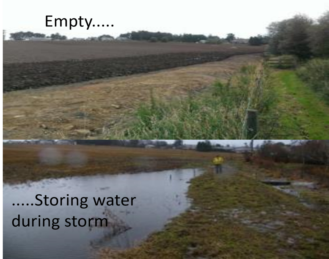
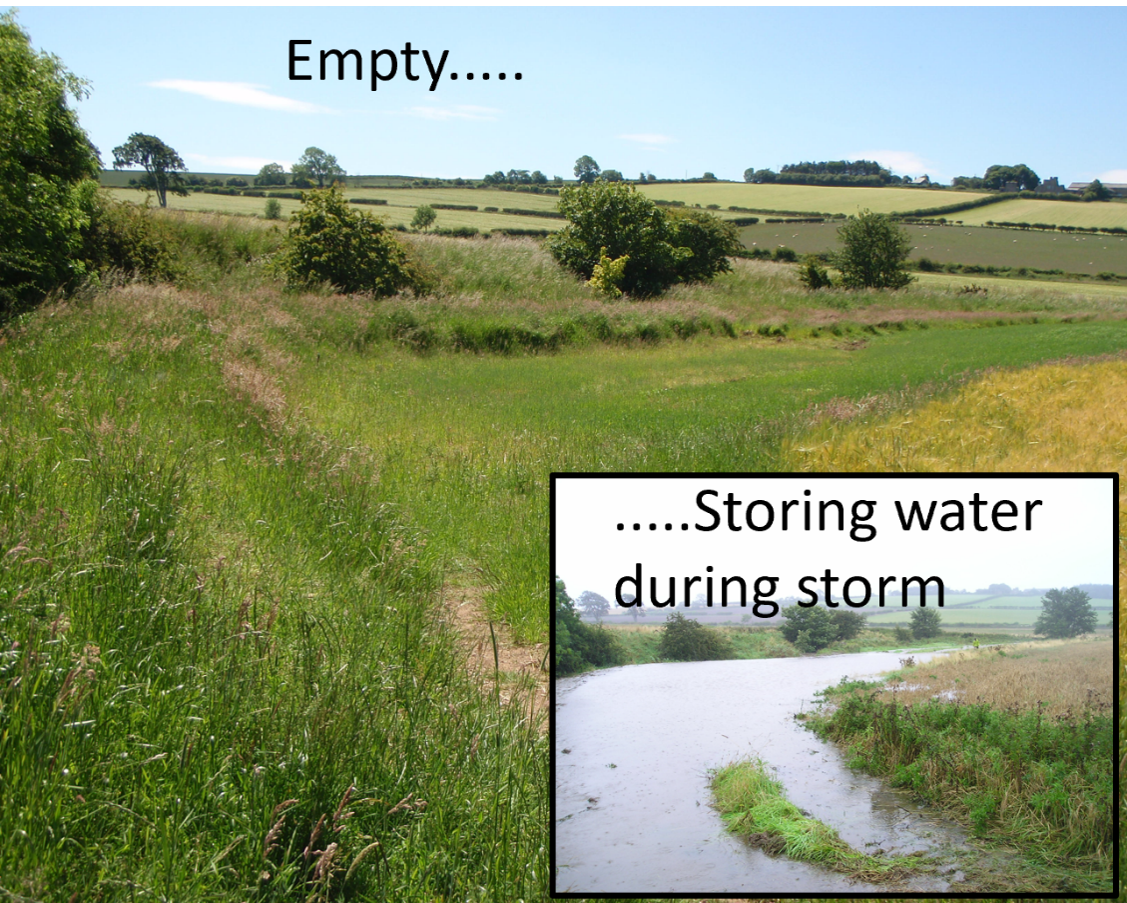
Raised buffer: field runoff
Raised buffer (temporary ponding of field runoff water and sediments)
Key concepts
A bund (usually constructed of soil, but can be timber or stone) placed across an overland flow pathway disconnects the pathway and temporarily stores surface run-off. The feature should have a designed spillway (in case of overtopping) and usually a pipe is placed through the bund to aid with draining. Pipe can be raised above the ground to allow some water retention for longer periods (which allows more sediment to settle and can increase recharge into the ground). Can be placed into the existing vegetated buffer (or edge of field margin).
These features can trap a large amount of sediment (and valuable topsoil), especially if the oulet drainage pipe is raised above the ground. They can provide a dry access route through the field for farm machinery. They do not affect farming productivity as much as more permanent wetlands as they drain shortly after a storm. For management purposes the bund height should generally be no more than about one metre.
Summary of evidence on functions
Wilkinson et al., (2013) showed that a raised bund buffer placed in a field margin (in the Belford catchment, UK) drained within 10 hours after mitigating runoff from an intense storm. It was estimated that the same feature captured ~1 tonne of sediment during a moderate rainfall event, the equvivalant of 91kg/ha (Palmer, 2012). There is a potential to create a complex habitat mosaic from wetter and drier ground that elevates the terrestrial habitat potential and other field services such as pollinators, but this depends on design and management.
Main countries where this is practiced
UK, Europe
Challenges and limitations, including site-specific factors, planning requirements and particular suitability to farming systems
Sediment accumulations need to be managed.
Space required, bund width is usually around 6 m to 8 m.
Bund will require ongoing inspections, especially after storm events. See guidance on how to construct measure - bunds need to be built correctly (e.g. spillway, pipe).
Ability to modify it for site requirements
Much scope to vary and tailor design/structure in line with nature of pollutant, loading and transport pathways.
Critical factors in establishment and ongoing management
Can be vegetated with a mix of grasses for extra stability to the bund.
Usually fenced off in a livestock field to ensure livestock do not damage bund. The diversity of wetter and drier soil conditions around the features aids habitat diversity (varying vegetation communities).
Expert effectiveness assessment: Averages from 25 international experts from an electronic survey during 2022-23.
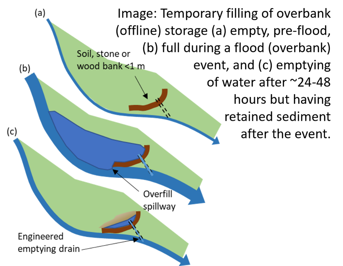
Raised buffers: overbank
Raised buffers and depressions (temporary ponding of channel water during overbank events)
Key concepts
These are simple low earthen banks (usually max. 1m high) constructed on floodplains to temporarily store floodwater during flood events These storage areas then drain back out into the watercourses after the main flood peak has passed downstream. The measure has a drainage outlet pipe and spillway. It should be placed to target suitable areas where floodwaters can be directed towards topographic depressions or relatively flat areas on the floodplain (to maximise amount of storage and minimise the volume of soil needed for bund). The storage areas and bunds are designed to permit the normal agricultural management of lower intensity grassland/meadow. In many lowland examples, these ponds can be created within wide vegetated buffer strips beside streams.
Summary of evidence on functions
Environment agency (2017) highlights the potential for offline storage areas to mitigate flood peaks (varying volumetric scales - some very small and very large e.g. washland). The same document highlights the multiple benefits of such features. Nicholson et al. (2019) showed that 35 small ponds (eachof capacity 500 m3in series in a 5 km2 catchment area) could provide a 30% reduction in flood peak for an observedstorm estimated to represent a 1:100 year return period (Hewett et al., 2020). Meltcalfe et al., (2018) also showed runoff attenuation features could be used to mitigate flood peaks .
Main countries where this is practiced
UK (for these smaller scale measures). Much larger scale measures (techical measures) are common in larger river systems in Europe and USA.
Challenges and limitations, including site-specific factors, planning requirements and particular suitability to farming systems
Needs a fair bit of space. However, the footprint of this measure can still be farmed.
Sediment accumulations need to be managed.
Space required, bund width is usually around 6 m to 8 m.
Bund will require ongoing inspections, especially after storm events.
Bund needs to be constructed correctly following correct guidelines.
It needs a control spill way and pipe. Need to confer with Lawpro, EPA and OPW for larger measures.
Ability to modify it for site requirements
Much scope to vary and tailor design/structure in line with nature of pollutant, loading and transport pathways.
Critical factors in establishment and ongoing management
Can be vegetated with a mix of grasses for extra stability to the bund.
Usually fenced off in a livestock field to ensure livestock do not damage bund. The diversity of wetter and drier soil conditions around the features aids habitat diversity (varying vegetation communities). Construction and management guidelines are currently being prepared by CIRIA
Expert effectiveness assessment: Averages from 25 international experts from an electronic survey during 2022-23.
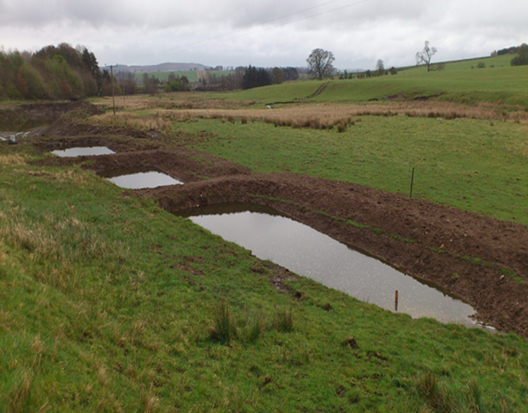
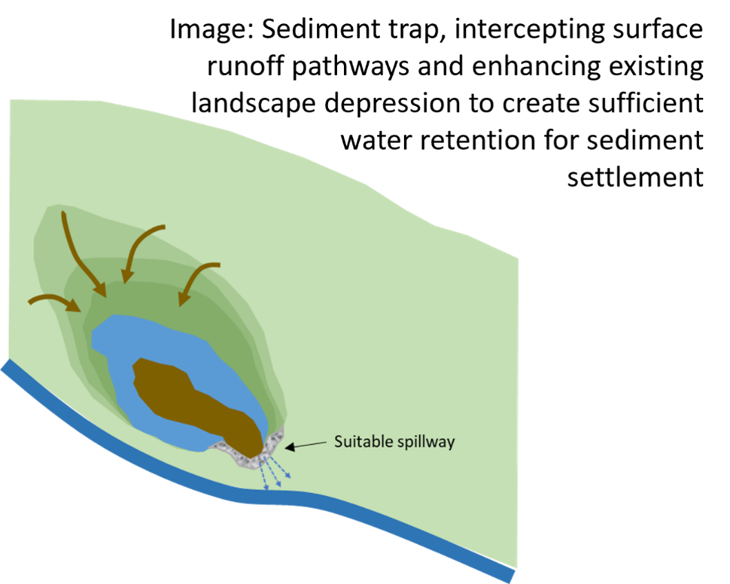
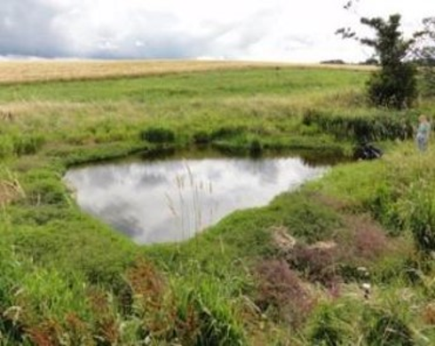
Sediment traps
Sediment traps increasing temporary water storage and sediment retention in depression areas
Key concepts
For areas where sediment and sediment transported contaminants degrade water quality a sediment trap is a useful point-based measure placed in an existing buffer zone uplsope of the watercourse banks. A closely related type of sediment trap that can be placed within an agricultural ditch is here described seperately. The measure is an engineered feature (or enhancement of an existing landscape depression), designed to hold back muddy run-off from fields and tracks, allowing time for suspended sediments to settle and usually has an outlet pipe or controlled spillway to spills excess flow.
It is usually better to have large surface areas as this allows more time for sediment to settle. Sediment traps may be placed upslope of another measure (e.g. a habitat measure) to protect it from a pollution burden and provide a managed point for extracting captured sediment.
Sediment traps are good for extreme erosion situations such as steep slopes, or exposed soil.
Summary of evidence on functions
A fair amount of reseach has been conducted into the functioning of sediment traps. Barber (2014) showed the potential for a series of sediment traps to capture sediment and P - the research highlighted that the second or third sediment trap in the sequence was more effective in mitigating P loads as finer particulates had longer time to settle. Novel sediment traps have also been conducted in the Defra Funded Demonstration Test Catchment Project in UK.
Mathers et al. (2021) highlighted that instream seidment traps distrupted the sediment regime, though impacts on instream ecology and environmental conditions were variable and system specific.
Main countries where this is practiced
U.S., Canada, New Zealand, Europe
Challenges and limitations, including site-specific factors, planning requirements and particular suitability to farming systems
Best with larger surface area, however, this takes a greater area of land.
Sediment traps should not be used to collect dirty water such as silage leakage, slurry or effluents as these should be treated considerable distances away from the riparian zone.
Sediment traps need management e.g. they need to be emptied.
See CREW document for guidance on how to construct a sediment trap
Ability to modify it for site requirements
Much scope to vary and tailor design/structure in line with nature of pollutant, loading and transport pathways.
Critical factors in establishment and ongoing management
In construction the area and volume and spillway flow rate should be designed for the potential runoff load rates for typical storms. Excavate the soil to an appropriate depth (remove to a safe place away from surface runoff pathways) and create gently sloping banks. Needs ongoing active management. This measure is designed to collect sediment and as a result this sediment will need to be removed.
Expert effectiveness assessment: Averages from 25 international experts from an electronic survey during 2022-23.
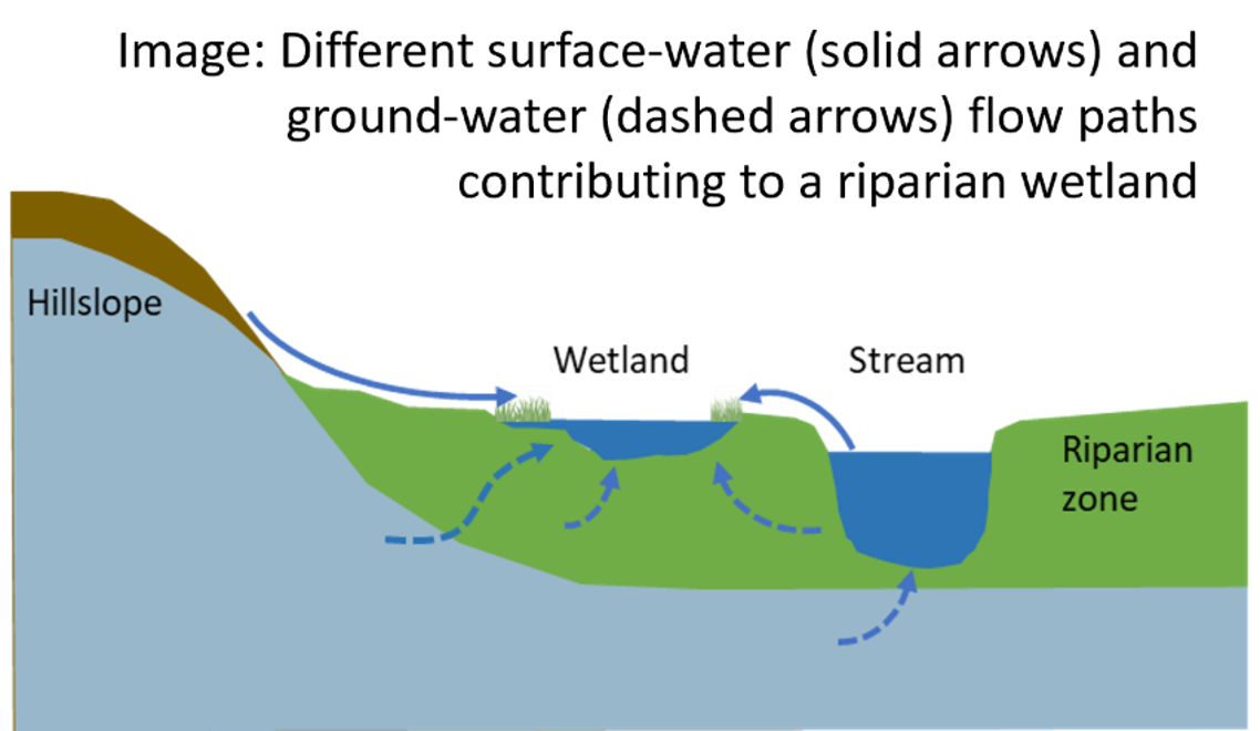
Surface-, ground- water wetland
Surface-, ground- water wetland
Key concepts
Wetlands are inundated with surface or ground water for long periods leading to a dominance of vegetation adapted to saturated conditions (including swamps, marshes, bogs and fens). Wetlands have very diverse habitats for plants, insects, birds, mammals, amphibians and filter runoff water by slowing water, depositing particles and prmoting microbial degradation of pollutants in high organic matter environments. Existing riparian wetlands can be enhanced or new ones formed in the riparian zone to enhance habitat diversity, water quality and control runoff rates. Wetlands should be designed to be permanently wet and can have varying depths and this may entail some design aspects and regulation of in/out flows. In grazing areas wetlands should be fenced off. Varieties of wetland can be diverse, including discrete wetlands (natural, restored fen, organic and mineral soil floodplains) and linear wetlands (wetland river banks, reaches of meandering or two-stage channel, both natural or restored - the latter related to the engineered two-stage channel measure in this database).
Summary of evidence on functions
Fossey & Rosseau (2016) used modelling to show Canadian river wetlands were effective in controlling flood flows and river droughts under climate change scanarios and that restoration was highly beneficial. The global meta-analysis by Kadykalo & Findlay (2016) showed wetlands deliver significant flow regulation but this is uncertainty in effect and prediction. Hoffmann et al (2011) assessed four river wetlands restored (remeandering, runoff diversion, fen re-establishment) and found annual retention per ha of wetland for P ranged from 0.13 to 10 kgP and N from 52 to 337 kgN, but the former was uncertain due to monitoring. Nutrient retention is strongly related to wetland hydrology and soil geochemistry, but functioning of newly restored/created wetlands for water quality is seldom investigated. River wetland restoration has potential for recreation and cultural benefits estimated as highly valued in European countries. Johnes et al (2020) showed that more permeable, groundwater fed wetlands in England had limited nutrient processing, being rarely 'wet' but transforming N and P to organic complexed forms that were periodically flushed.
Riis et al. (2020) highlighted the multifunctional role of riparian wetlands in delivering ecosystem services.
Challenges and limitations, including site-specific factors, planning requirements and particular suitability to farming systems
In a European context river corridor wetland restoration is closely related to valley bottom peatland restoration, with common issues of land management and ownership for contiguous restoration (e.g. linear features along a river).
Additional commonalities are in potential for climate change mitigation (lowering soil CO2 emissions from degraded peat/wetlands) and adaptation in buffering extreme water flows on floodplains and replenishing soil water.
Wetland areas are generally not compatible with CAP Cross Compliance.
Ability to modify it for site requirements
Critical factors in establishment and ongoing management
The diversity of wetter and drier soil conditions around the features aids habitat diversity (varying vegetation communities). When planning restoration the colonisation of a site restored by resculpting the ground surface and soil removal is important. Sites should be near to species sources, allow colonisation from downstream species (e.g. seed) transport or be assisted (especially in lowland agricultural landscapes where diverse species sources are depleted). Nutrient loading should be addressed at the site by additional measures to assist suitable wetland communities developing and restoration sites shold ideally be joined up via catchment planning. Risks of P mobilisation from the rewetting of degraded wetlands can be high at low Fe:P ratios (molar <10). This may have to be mitigated downstream or by removal of P enriched topsoil during works, which has high initial costs.
Expert effectiveness assessment: Averages from 25 international experts from an electronic survey during 2022-23.
Tile-drain fed wetland
Tile drainage fed to a surface water constructed wetland or small semi-natural wetland area
Key concepts
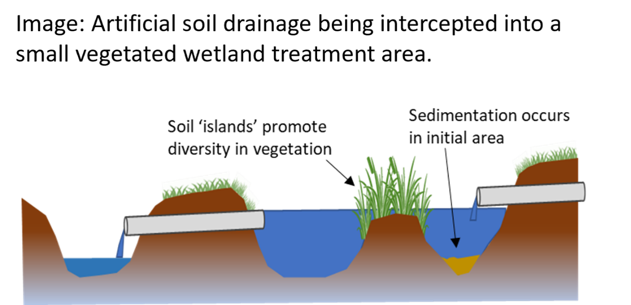
Intercepts water from a main subsurface artificial drainage and also maybe surface runoff. In the example of being routed to a small constructed wetland the draining water passes one or more deeper basins seperated by berms/raised areas planted with emerging (rooted underwater) vegetation. The deep zones increase residence time and the shallow zones supply organic matter to fuel denitrification. These have been used since the 1980s to mimick processes in natural wetlands. Many styles exist depending often on landscape position, the nature of the drainage being intercepted and the area required based on design principles of residence time for the site nutrient and water inflow rates. Cutting back small tile drains to an existing or enhanced mini-wetland area may be more proportionate management but water quality benefits would need to be judged against habitat change in the semi-natural small wetland. It should be noted that large constructed wetlands handling major pathways with high pollution loading, for example farm yard runoff, are NOT suited for treatment in riparian zones due to potential for plume migration in proximity to the watercourse. These larger systems should be sited safe distances upslope of riparian areas.
Summary of evidence on functions
The review by Carstensen et al (2020) on nutrient retention looked at designs of a subset of constructed wetlands recieving only subsurface tile drainage. The synthesis across 33 sites (17 scientific studies between 2000 to 2015) showed an average 41% (range -8 to 63%) reduction in annual nitrate loading. This approximated to average 60 gN/year reduction per m2 of wetland. The average total P reduction was 33% (range -103 to 68%) approximating to average 0.7 gP/year reduction per m2 wetland. For total P four sites showed a net P release with eleven sites a P sink.
Challenges and limitations, including site-specific factors, planning requirements and particular suitability to farming systems
Efficiences vary greatly depending on design (aspect, ratio of size to catchment affecting hydraulic residence time, carbon availability).
Wetland areas are generally not compatible with CAP Cross Compliance.
Several challenges of implementing constructed wetlands present barriers to landowner uptake, namely gaining planning permission and discharge licences.
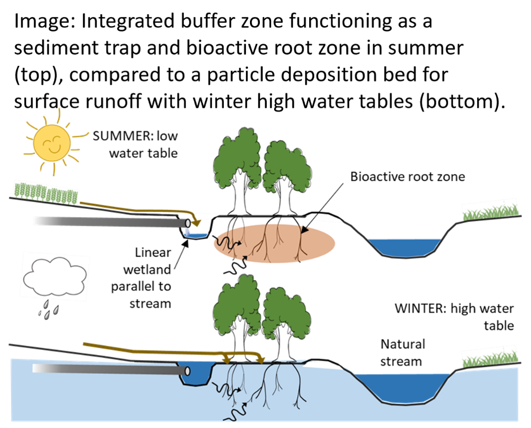
A multi-component measure intercepting surface runoff and artificial drain water in a linear wetland, then using a tree-planted section to further treat runoff water that is slowed in passage
Key concepts
This comprises a zoned buffer approach with integrated elements for higher pollution pressure locations. The erosion slope is interrupted by a ditch into which field drains are broken back from the stream. The ditch increases the residence time of nutrient-rich waters. Planted trees introduce a bioactive root zone, taking up nutrients into biomass, producing an energy crop, introducing habitat and stream shading. The stream bank remains a protected ecological zone. The measure brings a production element (biomass) to the buffer space aiming to alleviate accumulation of soil nutrients, tackles drain flows bypassing the buffer and increases particle retention for high erosion or clay-rich scenarios.
Summary of evidence on functions
Review of nutrient retention by Carstensen et al (2020) identified only one scientific publication. Zak et al. (2018) showed nutrient removal efficiencies of 26% for nitrate and 48% for total P, equivalent to 140 gN/year and 2.4 gP/year removal per m2 of the integrated buffer zone area. Relatively low retention was attributed to early vegetation establishment in the trials. Assessment for multiple benefits by Zak et al. (2019) found terrestrial habitat benefits were limited by lack of study duration but aquatic (especially amphibian) habitat benefits occurred rapidly. Biomass production was promising for offsetting costs and provided nutrient uptake. The main benefits can be summarised as:
Tackles field drain pathways and increases drain water residence time for treatment
Biomass crop placed downslope of temporary storage areas and uses tree root-zone to promote N, P retention/processing
Fine P sediments infiltrated on filter bed
Main countries where this is practiced
Scandanavia, Germany, UK (mostly trials highlighted in Zak et al. 2019)
Challenges and limitations, including site-specific factors, planning requirements and particular suitability to farming systems
There is limited testing presently as these are new concepts and designs mostly arising from the Danish led BufferTech project (~2015-18). More assessment is ongoing and further data are required to assess them properly.
Critical factors in establishment and ongoing management
Biomass harvesting periodically to maintain nutrient offtakes and produce biomass (may have value that offsets the management effort, especially if e.g. wood chip has on-farm, local use). Trees like Alder may have 10 year coppice cycles, willow may be 3-5 year cycles. In high erosion situations the linear pond may become sedimented such that retention time is reduced or field drain outlets become blocked. Then sediment will require to be manually emptied (better if accompanied by in-field erosion control).
Expert effectiveness assessment: Averages from 25 international experts from an electronic survey during 2022-23.
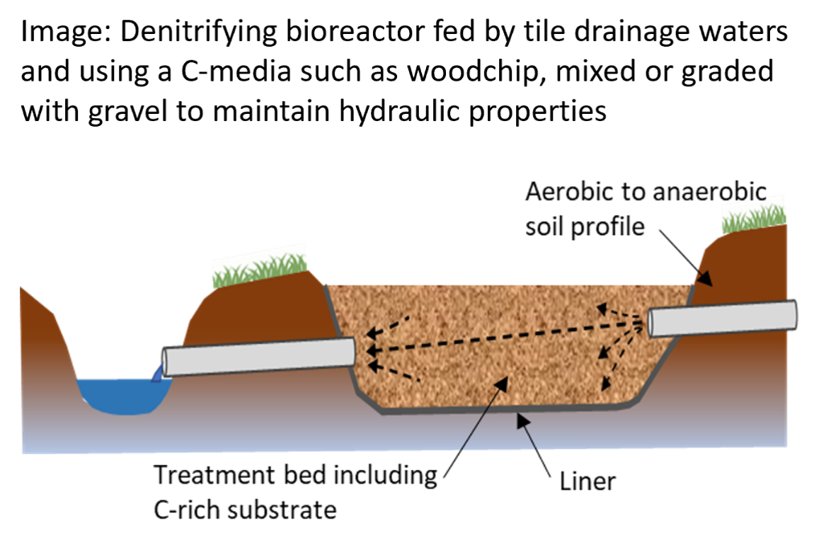
Denitrifying bioreactor
A fully engineered approach introducing flow through a bed of media with high available organic carbon to encourage microbial denitrification
Key concepts
Bioreactors reduce nitrate in subsurface waters in agricultural land in order to improve water quality. The bioreactor comprises a treatment bed containing a carbon source to promote dentrification. The drainage water is routed horzontally or vertically through a treatment bed with an enriched carbon supply. This can comprise woodchip or even experimental prototypes dosing with highly bioavailable liquid carbon sources. Often the media is mixed with gravel/soil to tune the infiltration and water residence times. Substrates may be open to air or buried with soil etc and the base is generally sealed with a non-permeable membrane.
Summary of evidence on functions
Carstensen et al (2020) provide a synthesis of nutrient retention across 19 sites (9 scientific studies spanning 2008 to 2019) showing an average 40% (range 6 to 79%) reduction in annual nitrate loading. This approximated to average 594 gN/year reduction per m2 of bioreactor (this originally being documented per m3 of volume). Only two studies recorded P balances and were condradictory: one showed total P release (-208% retention), another total P removal (26%; 6gP/year per m2 of bioreactor).
Main countries where this is practiced
U.S., some in Europe.
Challenges and limitations, including site-specific factors, planning requirements and particular suitability to farming systems
Nutrient removal efficiencies show strong variation between studied sites of differing N loads, bioreactor design and age.
Issues can be: water flows short circuiting the reactor substrate, inadequate sizing and in design of monitoring.
Many of the studied bioreactors are currently smaller experimental facilities.
Critical factors in establishment and ongoing management
Taken from USDA guidance:
Planning decisions: Do water samples show there is a need to reduce nitrate-nitrogen concentration in subsurface drainage flow? Do you have a good location at the edge of a field near an outlet pipe for a bioreactor?
A bioreactor should be designed to: Treat peak flow from a 10-year, 24-hour drain flow event. Treat >15% of the peak flow from the drainage system and >60% of the long-term average annual flow; Achieve >30% annual reduction in the nitrate-nitrogen concentration of water flowing through the bioreactor.
Media Chamber: Use a medium for a carbon source that is reasonably free from dirt, fines, and other contaminants. Distribute the media within the bioreactor for a uniform flow path. Use geotextile or plastic lining for the bottom, sides, and top of the bioreactor. Design the bioreactor for an expected life of at least 10 years.
Water Control Structures: Design water control structures to provide the required capacity and hydraulic retention time. Evenly distribute and collect water in the upstream and downstream ends of the media chamber. Allows for completely draining the media chamber to facilitate management and maintenance.
Expert effectiveness assessment: Averages from 25 international experts from an electronic survey during 2022-23.
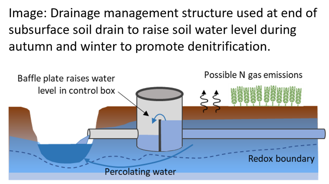
Controlled drainage
A control box fitted onto a major artificial subsurface soil drain allows impeding the water and nutrient exports in autumn-winter to wet up an area of field for denitrification
Key concepts
Field drain direct discharges to watercourses are managed and the soil is used to promote denitrification of drain waters. Controlled drainage utilises a control valve in the riparian zone to wet the upslope field area during periods of minimum required access and driving onto wet soils. The control valve can then be opened manually in spring before trafficking on field associated with cultivation. Baltic Compass trials report initial results that less overall drainage water is let out to streams/lakes, more ground water is formed and outlet of nutrients from drainage water are reduced such that overall agricultural soil N losses are reduced.
Summary of evidence on functions
Carstensen et al (2020) provide a synthesis across 25 sites (14 scientific studies between 1996 to 2018) showing an average 50% (range 19 to 82%) reduction in annual nitrate loading. This approximated to average 1.2 gN/year reduction per m2 of field (ie using the wetted field area). The average total P reduction was 34% (range -23 to 92%) approximating to average 0.03 gP/year reduction per m2 field. The total P reduction followed the reduction in drain flow volume.
Main countries where this is practiced
Denmark, Sweden, U.S.
Challenges and limitations, including site-specific factors, planning requirements and particular suitability to farming systems
Flat fields with permeable upper profile are suitable.
Baltic Compass recommends suitable fields as flat (<0.5% slopes), systematically drained with subsurface tile drains and medium to high degree of N in drainage waters.
A degree of engineering and management required.
Flat slopes require manual operation of control valves.
Site suitability guidance support online.
Limited knowledge in the context of UK.
Problems with lower denitrification occur where soil organic carbon is insufficient or where anoxic zones fail to establish.
Problems in raising water tables to reach higher soil crabon in topsoils are that surface runoff then becomes a risk, or crop yield is impacted.
Some concern that soil P stores suceptible to release under changing soil redox would be mobilised were not apparent in studies.
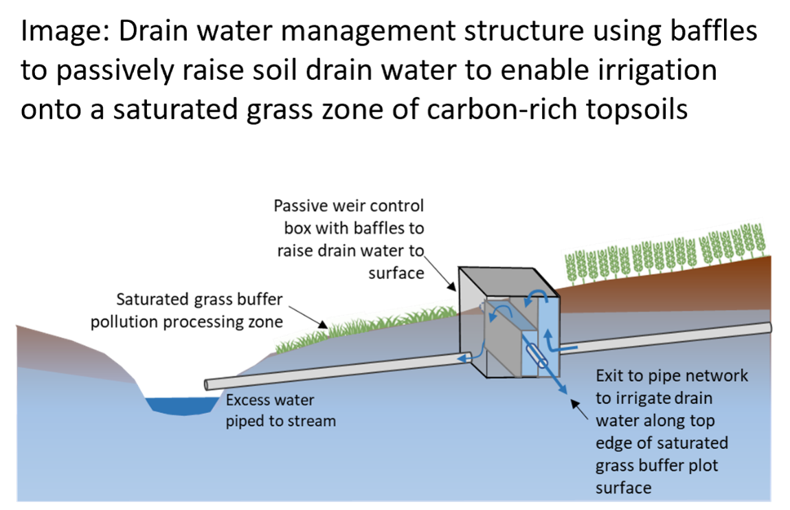
A control box fitted onto a major subsurface artificial soil drain raises the water allowing its irrigation onto carbon-rich topsoils to encourage denitrification in a saturated buffer
Key concepts
An edge of field measure that removes nitrate from subsurface tile drainage water before entering surface water drainage. A water control structure intercepts the tile drainage upslope of the outlet to the stream. This box contains a passive weir that raises the tile drain water level to the topsoil level. This pressure directs the water out through a slotted distribution pipe that runs along the top edge of a grass buffer perpendicular to the stream. The measure then allows the nitrate-enriched water to pass through the topsoils that are naturally higher in soil carbon than subsoils and to stream after time for microbial denitrification. To prevent failed drainage in the cropped field suitable slope prfiles are required. These should have a drop ~60 cm from the field across the buffer and the control box diverts water direct to the stream if the capacity of the buffer pipe is exceeded.
Summary of evidence on functions
Considered successful as a nitrate removal practice. Annually trials in Iowa have shown 7-92% removal of nitrate (average 42%) from the load at the tile drain. The effectiveness depends on the length of buffer (where excess water goes to the direct to stream bypass) and on a good loamy soil texture for percolation. A strong reduction in water NO3 concentration (to <0.3 mgN/L) occurred within 15-20 m of soil and this was proposed as denitrification. During 2015-17 monitoring identified whilst N2O losses were not significantly greater from these soils the potential to reduce N2O losses further down-system in the surface waters means the reconnection of tile drains to subsurface soils is not adversely affecting N2O GHG budgets.
Main countries where this is practiced
U.S.
Challenges and limitations, including site-specific factors, planning requirements and particular suitability to farming systems
Suited to arable and grassland sites where tile drainage is present and acting as conduits for transport of high nitrate concentration waters.
Requires sufficient space at the slope base for a saturated denitrification area with appropriate soil organic matter content.
Only applicable to appropriate slopes.
If too flat the raised water table at the slop base extends too far upslope of the control box into the field.
Length of buffer it discharges to should be designed according to expected flow (or too much water goes down the bypass direct to stream).
Ability to modify it for site requirements
If using at a flat site boards can be inserted into the weir control box to give manual control of raised water table. This means a flat denitrification buffer (and wet field area) can be made temporarily and removed prior to field operations such as trafficking (effectively acting as controlled drainage).
Critical factors in establishment and ongoing management
Annual inspection of the control structures for condition and removal of debris. Annual checking of pipes and tile outlet for erosion. Removal of woody vegetation near the outlet pipe and mowing/maintenance of the grass buffer area. Manual operation on flatter sites requires timely operation. Vigorous growing vegetation in the buffer is essential and should be promoted.
Expert effectiveness assessment: Averages from 25 international experts from an electronic survey during 2022-23.
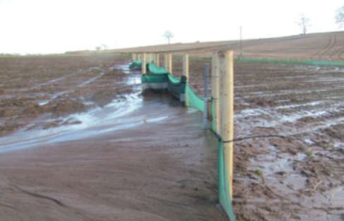
Sediment filter fence
A temporary measure capable of following an eroding crop in a rotation that traps gross sediment erosion behind a geotextile mesh fenced
Key concepts
Some sites with erosion risk (e.g. sloping, sandy textured soils, compacted soils) may be subject to cultivation practices that greatly enhance soil loss potential (e.g. potato cultivations). Where such activities are part of a crop rotation the risks may be large but only present in e.g. autumn each 4-5 years, then a temporary mitigation measure that can be set-up and moved may effectively follow a crop round a rotation. Filter fences comprise a geotextile material that is used for erosion control in construction and forestry projects to mitigate soil loss to watercourses. Placing this geotextile mesh material as a physical barrier (to soil, but allowing water movement) at the base of slopes can stop periodic gross erosion. The material is supported by standard stock fence posts that can be removed and used elsewhere the following year.
Summary of evidence on functions
Trials at the base of sloping field (10% slope) used for potato cultivation in Scotland showed capture of 80 tonnes of soil (60-70 kgP) from a 17 ha field on one season (Nov-Feb). The design used a textile net of 1.2 mm aperture, dug in at the base and pinned to a line of fence posts making a 146m long barrier. The accumulated sediment had similar chemical composition and bilk density to field soil (both high soil P status) but the trapped sediment was finer textured than in-situ soils. The sediment containing the highest P content was closest to the fence. Trials at Frogmary Green farm (LEAF demonstration farm) in England.on silty clay loam soils as temporary measures alongside cover crops.
Main countries where this is practiced
UK
Challenges and limitations, including site-specific factors, planning requirements and particular suitability to farming systems
Suited to highly eroding situations of landscape and cropping combinations.
Aimed at crop rotations where fixed mitigation measures may not be preferred due to infrequent years when risk is present.
Ability to modify it for site requirements
Fence lengths and strength (posts/length) can be altered for site conditions.
Critical factors in establishment and ongoing management
Benefits are maximised if trapped soil (and inherent nutrient content) is economically-viable to be moved back upslop onto the field, or it resides in a higher risk near watercourse location at slope base and must be stabilised by permant vegetation.
Expert effectiveness assessment: Averages from 25 international experts from an electronic survey during 2022-23.
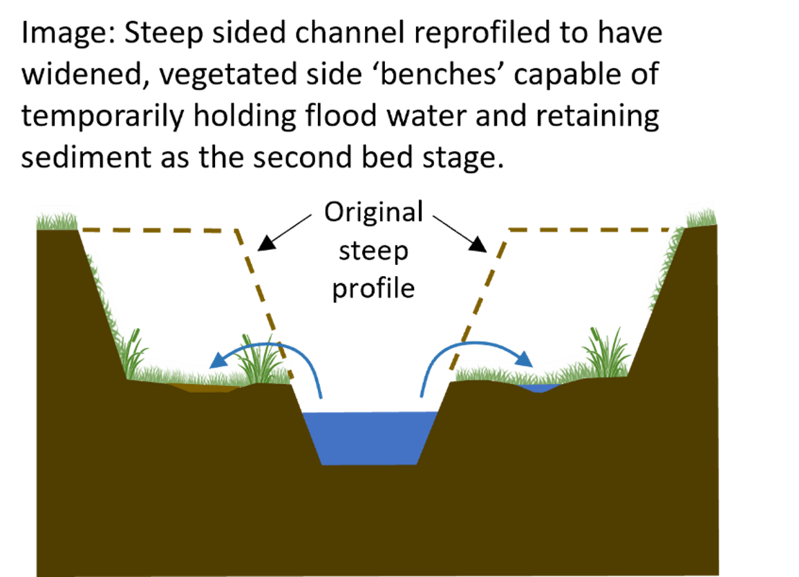
Two-stage channel
Reprofiling of a steep sided open drainage ditch allows flat channel sides to hold water and pollutants following high flows for processing.
Key concepts
Drainage is important for agricultural productivity but issues arise from conventional ditches that are oversize for small flows and have no floodplains (flushing out stored sediment) during high flows. Two stage ditchjes include the modification of the banks by addition of mini floodplain benches to mimic small natural floodplains but in engineered channels. In contrast a more traditional ditch has steep sides and V, or trapezoidal, profile. The floodplain benches allow the water to spread onto the vegetated mini floodplains during times of higher flows. The aim of this is to promote channel stability overall and deposit some of the load of sediments and bound nutrients. The feature takes little additional space out of agricultural production but may required long channel lengths to make a significant contribution. .
Summary of evidence on functions
In a study in the U.S. (Davis et al., 2015) found that total suspended sediment and toal and dissolved P forms were reduced in two-stage channels of former channelised agricultural streams during longer periods of floodplain inundation. A mmonium and nitrate only decreased for low N loading siuations. Examining 1.9 km of two-stage channel created in Minnesota, Krider et al. (2017) found the channel highly stable with low bank erosion risk, overall fluvial stability was increased during the change from the former conventional ditch, and divserity of key ins-stream habitat was improved. A review of studies across Finland (Västilä et al., 2021) showed improved water quality by retention of sediment, P and N on the created floodplains. The cost benefits of retained P and plant and fish biodivsity were 2.4 times greater than the costs of installation. Further studies on biodivertsity and long term performance were recommended. Balden et al (2021) studied the performance of designs in Austria over differing hydrological conditions. Sediments retained along two stage channel floodplains represented more those on natural floodplains than sedimentation in degraded streams and were less likely to act as in channel P sources.
Main countries where this is practiced
U.S., Scandanavia
Challenges and limitations, including site-specific factors, planning requirements and particular suitability to farming systems
The optimal location to reprofile the ditch to a two stage channel is where naturally channel benches (shoulders) are forming anyway.
The principles of design are that: the channel is sized to convey the effective discharge, the benches cut (the 'second stages') serve as the floodplain for the smaller inset channel and are adequate width to prevent flow overtopping the ditch and flooding surrounding land.
The designs seek to mimic features of a natural stream in adding roughness, slowing flows, providing channel stability and sedimentation.
Costs can increase if excessive tree roots are encountered or excavated material has to be reoved from site.
Ability to modify it for site requirements
A range of designs can be considered depending on the existing channel size, extent of floodplain formation naturally, sediment supply and flows encountered.
Critical factors in establishment and ongoing management
There is a capital costs for digging the new channel profile and removal of material and some land is required to be utilised to widen the ditch top. However, since the inset channel maintains faster flow than the benches the inset channel remains self-flushing and may require less period regular dredging.
Expert effectiveness assessment: Averages from 25 international experts from an electronic survey during 2022-23.
In ditch sediment trap or filter
Either a phsyical barrier of media such as wood, stone, or a widened pool to decrease flow velocity; both leading to local sedimentation in the channel and protection of downstream
Key concepts
In channel sediment traps include settlement bains widened into an existing channel, usually done on artificial open drainage ditches, to allow suspended sediment to settle out and collect. Another less common type that introduces filtration materials through which the water passes (e.g. stone, woodchip) are more specialised, as are those that are designed for use on natural streams where barriers to aquatic spewcies migration must be properly consulted on and designed. The action of sediment retention means cleaning out of sediment is required periodicially. There may be benefits of creating sediment pools for habitat diversity but also negative aspects of changing downstream inputs of resources such as woody material.
Summary of evidence on functions
Crows Hole main trap (built 2013 Arun & Rothers Rivers Trust) collected 1 m sediment depth, 65m3 and 72 tonnes mass within one year. Barber (2014) studied in ditch sediment traps and novel designs (e.g. bio reactive barriers). In ditch sediment traps are also discussed in this paper.
Main countries where this is practiced
U.S., Canada, New Zealand, UK
Challenges and limitations, including site-specific factors, planning requirements and particular suitability to farming systems
Traps can be installed to enhance existing areas of sediment accumulation (at slope breaks).
As a measure within the channels local restrictions may limit their use to artificial open drainage ditches (not directly into natural streams but instead treating drainage ditchs flowing into streams).
Sediment traps should not be used where they restrict the passage of migratory fish or eels.
Sediment traps should accompany other source controls to limit the runoff and sediment mobilisation.
All sites must have access for machinery to clean out sediment periodically from the trap with access from bank and not having machinery in the channel.
Ability to modify it for site requirements
The size and nature of the trap dimensions, location and incoproration of any filtration emedium can be altered for a given site.
Critical factors in establishment and ongoing management
Trap sizing depends on particle sizes and water velocities. Generally effective flow length should be twice the width, with gently sloping (not erodible) banks. Installation by widening an existing ditch section is common. Maintenance to clean out sediment is important and can be done easily at times the ditch is dry. If the ditch has flow in all seasons then windows of cleaning must be selected during suitable weather and low flows, avoiding key seasons for aquatic species in downstream waters. The following best management principles apply: prevent reslease of sediments downstream (e.g. a temporary silt fence can be used), avoid disturbing riparian vegetation, machinery must work from the bank not in the channel, work from one bank, remove deredged material a safe distance from the bank and ideally take back to fields. For the initial sediment trap construction the same principles apply.